THUNDER BAY — The province has released new details around its long-term plans to rebuild a stretch of Highway 61 in the Thunder Bay area, but a timeline for the improvements remains elusive.
Project leaders have presented preferred options that include eliminating traffic lights in favour of roundabouts and overpasses, eliminating highway access from Broadway Avenue, and extending Neebing Avenue across the Kaministiquia River.
Kevin Saunders of the Ministry of Transportation and Steve Taylor of consultant BT Engineering reviewed the preferred options in a presentation to Thunder Bay’s city council on Monday.
The MTO launched the preliminary design study in 2017, looking to establish an updated design for a 9.2-kilometre section of Highway 61 stretching south from the Thunder Bay Airport to just past Loch Lomond Road.
The changes are intended to improve safety and traffic flow, but may not be implemented for decades.
The MTO has called the stretch of highway a “major link,” with average traffic volumes around 24,000 vehicles per day at Arthur Street and 9,000 south of Loch Lomond Road, and expected to grow.
The study remains underway, with residents able to take a closer look at the designs and provide feedback at the second of three “public information centre” consultation meetings planned for early June.
The first public meeting was held in 2021.
The design is divided into two sections. In Part A, from the airport south to Chippewa Road, planners envision a freeway design with a barrier separating directions of traffic, and the elimination of traffic lights in favour of roundabouts and overpasses.
Chippewa Road itself would be routed over the highway using an overpass.
In Part B, south of Chippewa Road, the highway would transition to lower speeds and maintain some non-signalized intersections.
Asked about a timeline for implementing the changes, Saunders could not offer any estimates, saying the project remained “in the preliminary stages” and other work in the area took priority.
“As you might be aware, we’ve got a number of priorities within the region — we want to finish off the Thunder Bay-to-Nipigon corridor … and of course, the Thunder Bay Expressway is a big priority.”
“When the change does come around where we can get at this corridor, then we’ll pull this off the shelf and have a look at it. But this is more just long-range planning.”
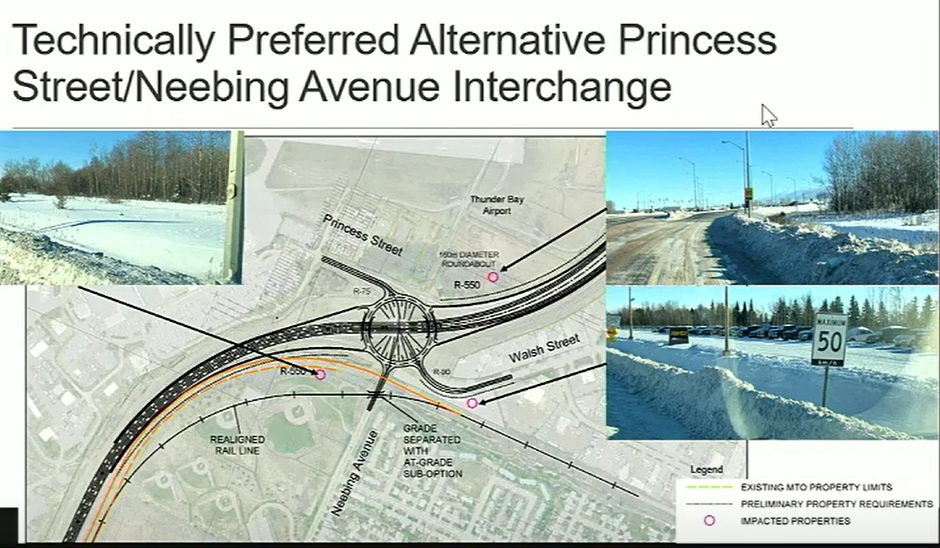
In perhaps the most significant change, the intersection at Princess Street and Neebing Avenue would see the highway lowered to pass below a new roundabout connecting seven routes including Princess, Neebing, and Walsh.
Planners said the roundabout design was as compact as possible, but would still require the realignment of a nearby CN Rail line, cutting into the Westfort Playfield, a city park that hosts several baseball diamonds.
“It does have effects on the recreational area owned and operated by the city,” Taylor said. “But because of the constraint of the airport, the expansion of the road network was requiring a change in that area.”
The possibility of the disruption was communicated to the city as early as 2021, he noted.
The preferred design would eliminate highway access via Broadway Avenue, instead lowering the highway by six to seven metres to route it beneath Broadway.
Broadway would connect with an extended Neebing Avenue on the east side of the highway that would serve as the main route into the urban area.
That option avoids impacts to the nearby Mountainview and St. Patrick’s cemeteries and will promote safety by removing ramps, planners say, as well as bringing “significant cost savings.”
“What came out of our early engagement with the community was to look at a new solution that provided a municipal road connection parallel to Highway … and avoid a direct interchange at Broadway Avenue,” said Taylor.
The extended Neebing Avenue is envisioned to eventually cross the Kaministiquia River parallel to the highway and terminate at Chippewa Road.
The second part of the plan envisions one roundabout, at the highway’s intersection with 20th Side Road and Mountain Road.
Highway access from nearby Cavar Road and Loch Lomond Road is proposed to be eliminated, with new connections built to instead link them to the local road network.
The second of three public information centre meeting is planned for early June, but neither a date nor venue have yet been identified, Saunders said.
