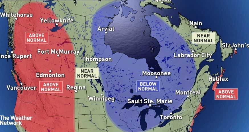
THUNDER BAY — According to one weather forecasting service, those lazy, hazy, crazy days of summer may be fewer and farther between in Northwestern Ontario this year.
Meteorologists with The Weather Network believe a developing "rather significant" El Nino event portends an overall cooler June-to-August period compared to recent years in the eastern half of Canada, including the Northwest.
El Nino occurs when the water in some parts of the Pacific Ocean heats up and moves toward the west coast of North America, which impacts the path of the jet stream.
"While there will be periods of hot weather, the heat will lack commitment, especially in the northern parts of the province. Frequent cold fronts will bring periods of cooler weather, which should more than offset the periods of hot weather, resulting in slightly cooler than normal temperatures for the season," The Weather Network said Wednesday in its official summer forecast for Ontario.
It said rainfall is expected to be below or near normal across Northwestern Ontario.
Environment Canada agrees that June is likely to be drier than normal in the region, but it's hesitant about looking farther into the summer with any significant degree of certainty.
In an interview Wednesday with TBnewswatch, meteorologist Monica Vaswani said the current warm spell should continue through the first week of June before temperatures start to edge back toward normal.
"Beyond those two weeks, it does get a little more difficult to say, to be more specific for the remainder of June. But June as a whole for Northwestern Ontario right now, it is looking generally like above-seasonal conditions should persist."
"Once we get into July and August, it does get a little muddier, unfortunately."
She said forecast models in some cases are indicating it will be warmer than usual, and in other cases cooler than usual.
"The farther out we get in a weather forecast, generally speaking, the higher degree of uncertainty there is ... We'll have to see what happens in July and August."
With regard to the impact of El Nino, Vaswani said the phenomenon can definitely impact temperatures in Canada, but if often has a more significant effect in the winter months than in the summer.
"As a result of that, it does make it more difficult to sort of attribute El Nino to any one particular temperature trend. The other thing is in the summer months in general, because of convection — the thunderstorms we see in the summer — we can get big swings in temperature, just because of, for example, a heavy rain shower. And we can also get large swings in precipitation values for the exact same reason between one community and another just 20 kilometres away."
In the U.S., the National Weather Service agrees that the developing El Nino adds uncertainty to what might happen this summer.
But its current long-range outlook calls for an equal chance of below-normal, near-normal and above-normal temperatures in the region bordering Northwestern Ontario
The U.S. National Oceanic and Atmospheric Administration has issued the same outlook for northern Minnesota, and has also noted that El Nino's impact on summer weather is often unreliable.
